KANCHANABURI TOUR MAP
Places to visit in Kanchanaburi : A Map of Top Tourist Locations

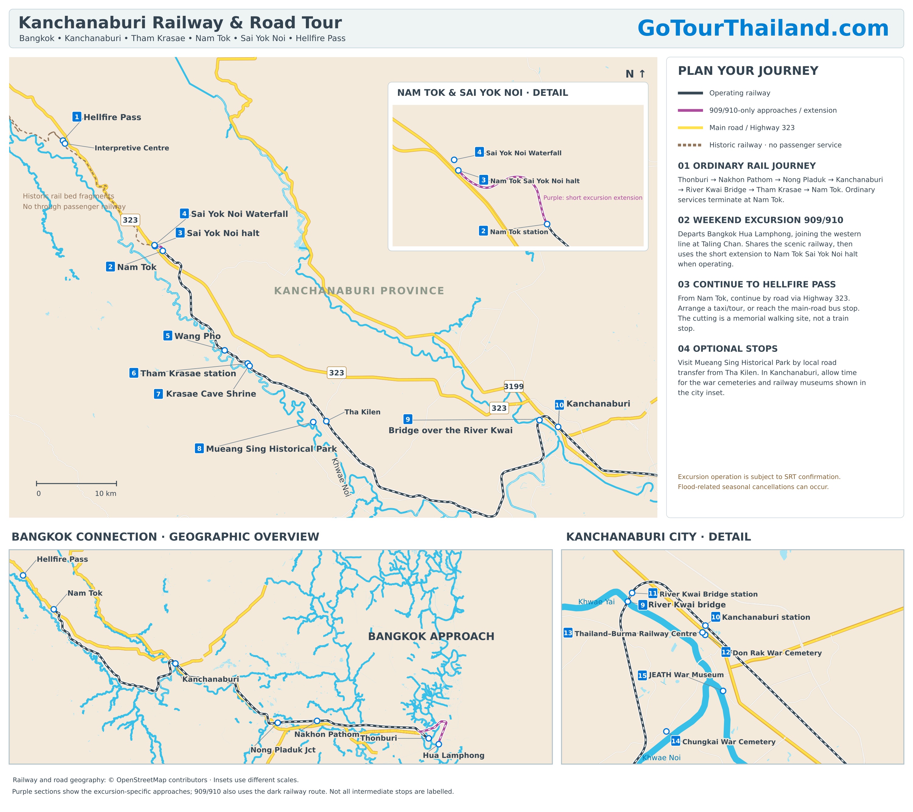
The Death Railway, River Kwai Bridge, Hellfire Pass Tour Map
Distances use Kanchanaburi Railway Station as the city-centre starting point. Road distances and driving times are approximate estimates for a car or taxi, excluding stops and traffic delays. Train times exclude waiting for departure.
-
1 Hellfire Pass
Address: Hellfire Pass Interpretive Centre, 207 Moo 11, Tha Sao, Sai Yok District, Kanchanaburi 71150. Access is from Highway 323.
By road: Approximately 80–85 km; 1–1½ hours to the centre. Allow additional time to walk down to the cutting.
By railway: Travel approximately 77 km to Nam Tok, taking 1 hour 35 minutes–2 hours, then continue approximately 20 km by road, taking 20–30 minutes. No passenger railway reaches Hellfire Pass.
-
2 Nam Tok Railway Station
Address: Tha Sao Subdistrict, Sai Yok District, Kanchanaburi 71150.
By road: Approximately 63 km; 1–1¼ hours.
By railway: Approximately 77 km; 1 hour 35 minutes–2 hours. This is the terminus for ordinary passenger trains.
-
3 Nam Tok Sai Yok Noi Halt
Address: Ban Tha Sao, Moo 3, Tha Sao, Sai Yok District, Kanchanaburi 71150, beside the waterfall area.
By road: Approximately 63–65 km; 1–1¼ hours.
By railway: Approximately 79 km along the railway. Served by the 909/910 excursion when operating, with journey time dependent on its sightseeing programme. Ordinary trains end at Nam Tok, approximately 1.4 km before this halt.
-
4 Sai Yok Noi Waterfall
Address: Moo 3, Tha Sao, Sai Yok District, Kanchanaburi 71150, beside Highway 323.
By road: Approximately 63–65 km; 1–1¼ hours, followed by a short walk from the parking area.
By railway: Travel approximately 77 km to Nam Tok, taking 1 hour 35 minutes–2 hours, then continue approximately 1.5–2 km by local road, taking 5–10 minutes by vehicle. Excursion passengers can walk from Sai Yok Noi halt.
-
5 Wang Pho Railway Station
Address: Wang Pho village, Lum Sum Subdistrict, Sai Yok District, Kanchanaburi 71150.
By road: Approximately 53–55 km; 50–65 minutes.
By railway: Approximately 61 km; 1 hour 15 minutes–1 hour 30 minutes. Wang Pho is a separate station beyond Tham Krasae.
-
6 Tham Krasae Railway Station
Address: Lum Sum Subdistrict, Sai Yok District, Kanchanaburi 71150, beside the Tham Krasae wooden viaduct.
By road: Approximately 50–53 km; 50–65 minutes.
By railway: Approximately 57 km; 1 hour 5 minutes–1 hour 25 minutes, depending on the service and stopping point.
-
7 Krasae Cave Shrine
Address: Beside the Tham Krasae viaduct, Lum Sum Subdistrict, Sai Yok District, Kanchanaburi 71150.
By road: Approximately 50–53 km; 50–65 minutes, followed by a short walk from the visitor parking area.
By railway: Travel approximately 57 km to Tham Krasae, taking 1 hour 5 minutes–1 hour 25 minutes, then walk to the cave beside the railway.
-
8 Mueang Sing Historical Park
Address: Sing Subdistrict, Sai Yok District, Kanchanaburi 71150.
By road: Approximately 40–43 km; 45–60 minutes.
By railway: Travel approximately 45 km to Tha Kilen, taking 50–70 minutes, then continue approximately 2 km by local road, taking 5–10 minutes by vehicle. Arrange the transfer beforehand.
-
9 Bridge Over the River Kwai
Address: Maenam Khwae Road, Tha Ma Kham, Mueang Kanchanaburi District, Kanchanaburi 71000.
By road: Approximately 3 km; 5–10 minutes.
By railway: Travel approximately 3 km to River Kwai Bridge station, taking about 5 minutes, followed by a short walk to the bridge.
-
10 Kanchanaburi City and Railway Station
Address: Kanchanaburi Railway Station, off Sangchuto Road, central Kanchanaburi, Mueang Kanchanaburi District, Kanchanaburi 71000.
By road: 0 km—the city-centre reference point used for this list.
By railway: The starting station for the railway distances and journey times listed here.
-
11 River Kwai Bridge Station
Address: Saphan Khwae Yai station, near Maenam Khwae Road, Tha Ma Kham, Mueang Kanchanaburi District, Kanchanaburi 71000.
By road: Approximately 3 km; 5–10 minutes.
By railway: Approximately 3 km; about 5 minutes. The platform is beside the bridge visitor area.
-
12 Don Rak War Cemetery
Address: 284/66 Sangchuto Road, Ban Tai, Mueang Kanchanaburi District, Kanchanaburi 71000.
By road: Approximately 300–500 metres; 2–5 minutes. Walking generally takes 5–10 minutes.
By railway: No separate train journey is needed; walk from Kanchanaburi station.
-
13 Thailand–Burma Railway Centre
Address: 73 Chao Khun Nen Road, also written Jaokannun Road, Ban Nuea, Mueang Kanchanaburi District, Kanchanaburi 71000.
By road: Approximately 400–600 metres; 2–5 minutes. Walking generally takes 5–10 minutes.
By railway: No separate train journey is needed; walk from Kanchanaburi station.
-
14 Chungkai War Cemetery
Address: Highway 3228, Tha Ma Kham, Mueang Kanchanaburi District, Kanchanaburi 71000, on the west bank of the Khwae Noi River.
By road: Approximately 5–6 km; 10–15 minutes, depending on the river crossing used.
By railway: A local road transfer is the practical option; there is no station at the cemetery entrance.
-
15 JEATH War Museum
Address: Within Wat Chai Chumphon Chana Songkhram, near Pak Phraek Road, Ban Tai, Mueang Kanchanaburi District, Kanchanaburi 71000.
By road: Approximately 2.5–3 km; 5–10 minutes.
By railway: No direct rail connection; take a local road transfer from Kanchanaburi station.
This is the original JEATH War Museum at Wat Chai Chumphon.
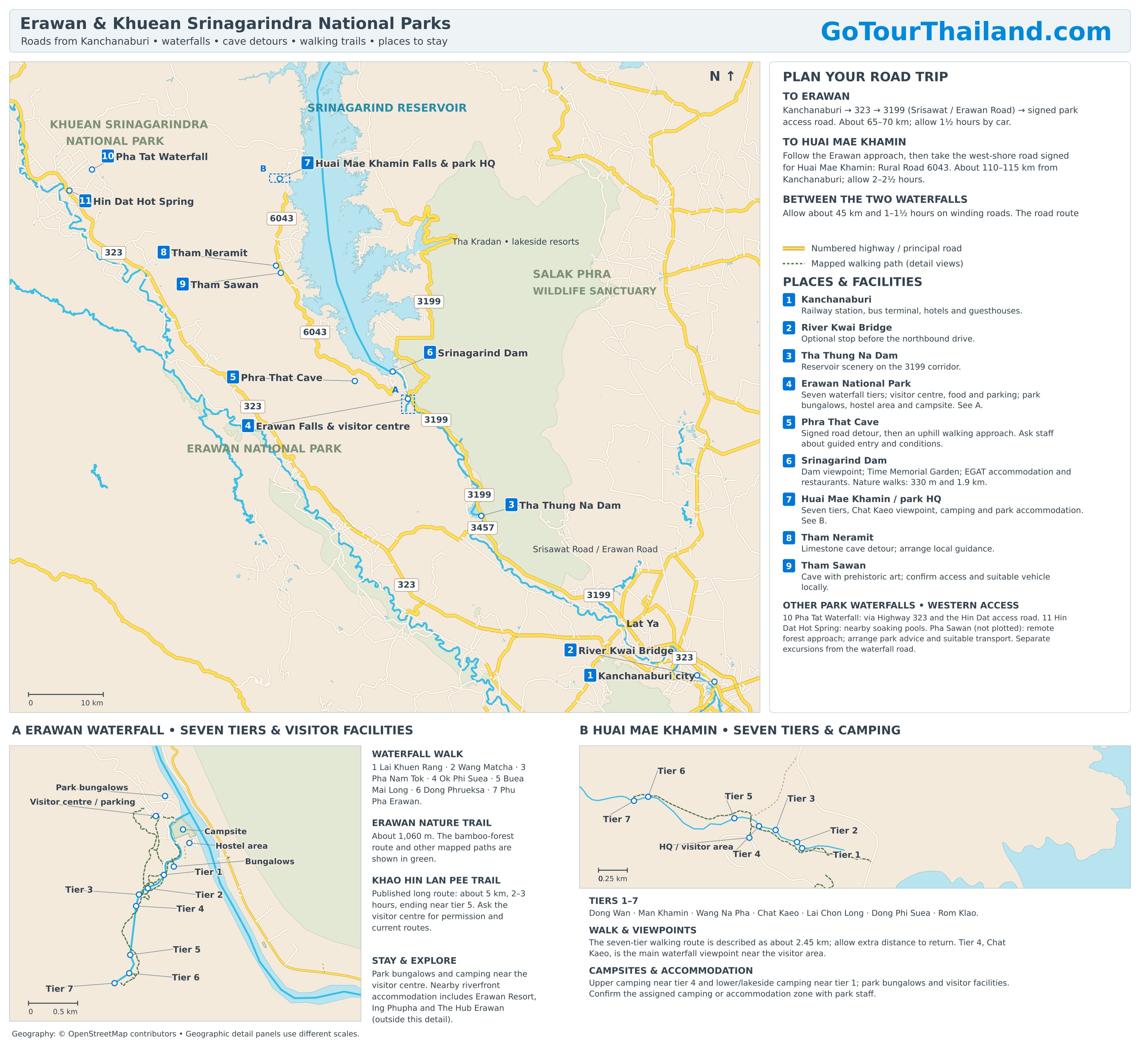
Erawan National Park and Khuean Srinagarindra National Park Tour Map
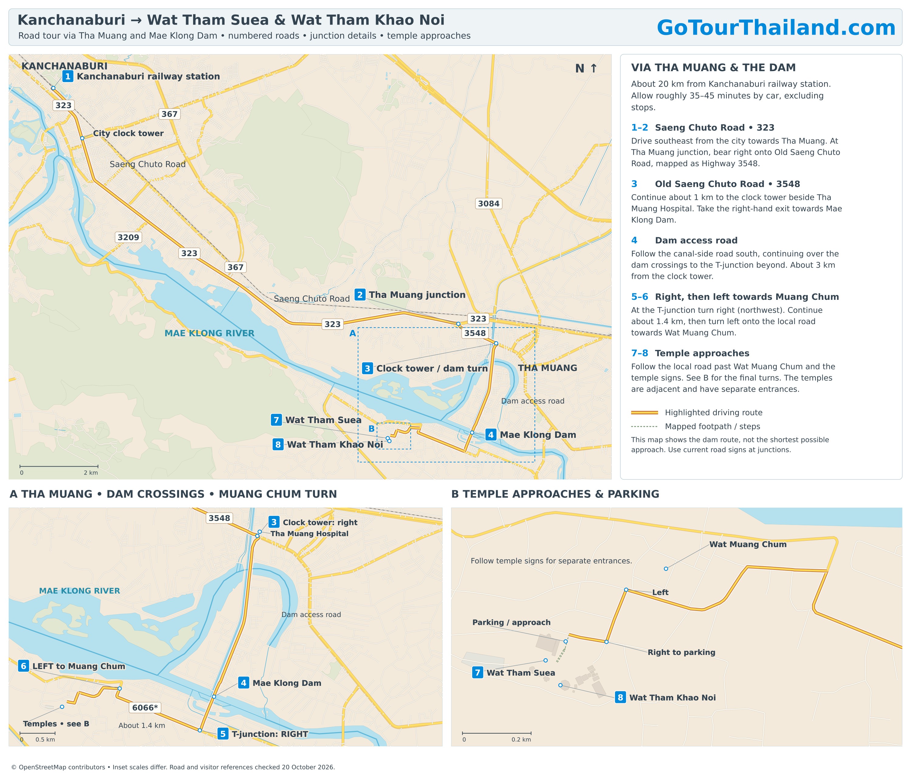
Kanchanaburi Wat Tham Suea & Khao Noi Road Tour Map